By Cynthia Zaitzevsky
Proceedings of the Brookline Historical Society.
Fall 1977, pp. 42-65.
(Brookline Public Library: [Brookline Room] 974.45 B77hn)
CONTENTS
- INTRODUCTION
- PARKS: The Muddy River Improvement
- SUBDIVISIONS
- STREET IMPROVEMENTS
- SUMMARY
- NOTES
- ILLUSTRATIONS
- AUTHOR
- FALL MEETING
INTRODUCTION
Frederick Law Olmsted, Sr.1 (1822-1933) is celebrated for the design of Central Park, New York City and the Boston park system. Most Brookline residents are now aware that Olmsted lived and had his office in Brookline for many years, but few probably realized the extent of his actual work in the town.
Born in Hartford, Connecticut, Olmsted took several years to settle on a career. He did not immediately become a landscape architect, for there was no such profession at the time. In the 19th century, the design of private estates was the task of landscape gardeners, while large-scale public projects were usually laid out by civil engineers. Olmsted was the first to combine the two specialities.
In 1857, he and an English-born architect, Calvert Vaux, submitted a design in the competition for Central Park. Their plan won the prize and attracted nation-wide attention. During the Civil War, Olmsted resigned to become Executive Secretary of the United States Sanitary Commission (predecessor of the American Red Cross). The fame of Central Park brought many other commissions to Olmsted’s office. Brooklyn, then an independent city, laid out Prospect Park from Olmsted’s and Vaux’ plans. In 1869, the firm designed an entire community at Riverside, Illinois.
Olmsted’s national practice continued, but, by the early eighties, much of his work was near Boston. In 1883, he bought the Clark house on Warren Street for his permanent home and office. His choice of Brookline was influenced by the fact that his friend, the architect H. H. Richardson, lived here. The Warren Street house was only a short walk from Richardson’s house on Cottage Street and from “Holm Lea,” the home of Charles Sprague Sargent. Sargent was the Director of the Arnold Arboretum in Jamaica Plain, which Olmsted had also designed. Olmsted considered Brookline a particularly advanced community. During the Civil War, he had been much impressed by Brookline’s generosity to the Sanitary Commission. (“With Brookline,” he said, “it is deeds, not words.”)2 The story also goes that, while visiting Richardson one winter, he woke up early on a snowy morning and was surprised to see the horsedriven plows already out and at work.
Records in the files at Olmsted Associates show that the firm has designed more than 200 projects in Brookline from about 1880 down to the present day. While all of these should eventually be studied and documented fully, the present paper will deal only with projects from the first generation of the firm (until the retirement of F. L. Olmsted, Sr. in 1895) and with projects of a public scope. The many plans which the firm did for the grounds of institutions and private homes will not be considered at this time.
The public projects fall into three general categories: parks, subdivisions, and street widenings or new streets.
PARKS: The Muddy River Improvement
Boston, since it was confined to a peninsula, had at first no space for large parks, but, by the mid-1870’s, its boundaries were enlarged by the annexations of several cities and towns. (Brookline, as we know, rejected annexation.) In 1875, Boston appointed a Park Commission and began to plan an ambitious park system that would surpass even those of New York City and Brooklyn.3
After a competition for the Back Bay Fens failed to produce a workable design, Olmsted was called in to lay out this park. He eventually designed all the components of the Boston park system. Although the legislation establishing the Boston Park Commission allowed adjacent cities and towns to lay out parks in conjunction with Boston, Brookline was the only community to take advantage of this provision. In 1880, Brookline elected a threeman Park Board and proceeded to work with Olmsted and the Boston Commissioners on a plan for improving the valley of the Muddy River.
The growing pollution of this winding tidal creek had concerned townspeople for some time. Its brackish waters bred a malarial mosquito, and its shores were becoming crowded with shacks. The Brookline Commissioners, led by Charles Sprague Sargent, worked for almost fifteen years to make Olmsted’s plan for the “Sanitary Improvement of the Muddy River” a reality.
Riverway – View from Longwood Bridge, Looking North
Leverett Pond
The land that was incorporated into this park falls into two topographical units: from the end of the Fens at Brookline Avenue to Tremont Street (now South Huntington Avenue) and from this point to Perkins Street above Ward’s Pond. The first segment, or the Muddy River proper, is now commonly called the “Riverway,” although, according to Olmsted’s nomenclature, this title belongs only to the parkway on the Boston side. David Sears’ land originally lay on both the Brookline and Roxbury sides of the lower Muddy River. The Romanesque revival tower of his family chapel has always caught the eye along this stretch of the park, which is often referred to as “Longwood,” after the neighborhood as a whole (Figure 1). Both banks of the Muddy River from Longwood up to Brookline Village were completely recontoured and planted with native trees and shrubs.
The second segment was originally called “Leverett Park,” after the pond which is its dominant feature. In 1900, Jamaica Park and Leverett Park were renamed Olmsted Park. Leverett Pond is an artificial body of fresh water, constructed by Olmsted from the malarial swamp near Brookline Village (Figure 2). The working class housing that formerly stood on the site of the present Brook House was retained on the border of the park, and only some “condemned” buildings on Downer Street (itself eradicated by the park) were torn down.4 Most of the Muddy River Improvement is thus manmade, the exceptions being Ward’s Pond and the knolls around it, as well as the meadow in Boston which is now Daisey Field. At Ward’s Pond, the main work of construction was the building of paths. Around the turn of the century, it was lavishly planted with mountain laurel and rhododendron.
Olmsted’s first plan, published in January of 1881, retained the natural meandering line of the Muddy River. Later, however, he advised changing it to a more regular course. An Act of the State Legislature was necessary to do this, since it involved changing the boundary between Boston and Brookline. Other delays occurred when the Brookline Commissioners ran into problems purchasing land and when the Boston Commissioners had to postpone construction while they waited for an appropriation. The design that was finally executed was Olmsted’s Revised Plan of 1890, which included the changed line of Muddy River, the meadow in Boston and a series of natural history pools (later filled in) between Leverett and Ward’s ponds. It also included, at Olmsted’s strong suggestion, two roads on the Brookline side between Brookline Village and Perkins Street: the inner parkway for pleasure traffic only and the outer road for access to the residences along Pond Avenue.
After Richardson’s death in 1886, Olmsted collaborated frequently with his successor firm, Shepley, Rutan and Coolidge. They designed all the granite bridges in the Muddy River Improvement from the preliminary drawings of John Charles Olmsted, Olmsted’s step-son and partner. The Olmsted firm prepared detailed planting plans for the Brookline side of Muddy River, which were carried out by a Brookline planting crew under the direction of Charles Sprague Sargent. Olmsted and the Boston Park Commission’s chief gardener W. E. Fischer, designed the planting of the Boston side by eye on the site.5
With time, much of the planting has eroded, maintenance has become a problem, and the “chain of pleasant waters” envisioned by Olmsted has become clogged with silt. Nevertheless, there have been no major intrusions in the Muddy River Improvement, and this park has much potential for restoration.
SUBDIVISIONS
The second category of public projects designed by Olmsted in Brookline is subdivisions. Unlike parks and streets, which are normally sponsored and paid for by a city or town, subdivisions are generally done for a private client; but the character and size of these projects gives them a public dimension. A subdivision creates a neighborhood.
Even before Olmsted’s appearance on the scene, Brookline had a tradition of enlightened town planning. Like other communities around Boston, it was making the transition from farming village to “streetcar suburb,” but with minimum damage to the topography and character of the town. An important early example of progressive planning was the subdivision of “Longwood.” In 1848, David Sears engaged Alexander Wadsworth, a gifted civil engineer who had been involved in the design of Mount Auburn Cemetery, to lay out his estate as a parklike residential neighborhood, dotted with squares and planted with thousands of specimen trees. Another such example is “Fairmount,” later called “Lakeside,” laid out by J. A. Williams in 1849 next to Brookline Reservoir. (Plans for both these subdivisions are located in the map collection of the Brookline Public Library.)
Why were Brookline subdivisions “advanced” even before Olmsted’s time? There are several possible reasons. In the first place, it was a wealthy town, and the pressure simply to make money was not as great as in many other communities near Boston. Secondly, there was a general awareness of the town’s beauty and a highly developed civic consciousness: people tended to get together to make a project better, as David Sears and Amos Adams Lawrence had at Longwood. Furthermore, after the mid-1870’s, Brookline stood out particularly sharply among its neighbors, for it was never developed as aggressively as the annexed towns.
Brookline was also fortunate in that many of the subdivisions designed by both Olmsted and his predecessors were on a generous scale, thus giving a consistent visual character to large sections of the town. Even the smaller subdivisions, such as “Fairmount” and, later, the land laid out by Olmsted for Edward S. Philbrick on the top of Pill Hill, tended to blend in a sensitive manner with existing street patterns. In this way, the crazy-quilt effect of contigious but unrelated subdivisions, found frequently in parts of Cambridge and the annexed areas of Boston, was avoided.
A related advantage was the kind of owner/developer frequently found in Brookline. After the Civil War, farms and estates near urban areas throughout the country were rapidly bought up by speculators. The usual situation occurred when an old family died and the land was bought by a speculator, who laid out roads, lots, sold the lots and then had no further connection with the project. (Speculators generally sold lots directly to owners then and did not build the houses.) In Brookline, the owner of a large estate often decided to subdivide and then to continue living on part of his property. This was the case in the mid-19th century with Sears and Lawrence and later with most of Olmsted’s clients. Obviously, this situation would lead to a more sensitive solution, since the owner had to live with his own development.
Speculatively built subdivisions were generally laid out with little regard for natural topography. The easiest and cheapest way to subdivide a parcel of land was to lay it out in a grid pattern: a checkerboard type of plan with parallel roads and standard-sized, rectangular lots, all facing on through streets.6 Such a plan had a certain logic on flat land, but it was an insensitive way to treat the irregular glacial landscape of New England. As can easily be observed, there is little flat land anywhere in Brookline. Although Longwood and Cottage Farm, being laid out in part on filled salt marsh and cedar swamp, are relatively level, even this district rises noticeably from east to west. Brookline’s topography is dominated by drumlins, the largest of which is Corey Hill, and these were the last parts of the town to be intensively developed. By the early 1880’s, Brookline’s growth had reached a critical point. The hillside properties of old Brookline families and of wealthy summer residents were coming on the market. At Riverside and in other community designs, Olmsted had used a curvilinear type of plan, which, unlike the standard grid, could be accommodated to irregular topography. Most of Olmsted’s Brookline subdivision plans were for such hillside sites, e.g. Fisher Hill, Pill Hill, Aspinwall Hill and Corey Hill.
Olmsted is known to have prepared plans for at least six subdivisions in Brookline between 1880 and 1895.7 Of these only two were executed as planned. What happened? There was probably a different reason in each case, but it is important to remember that Olmsted was a new man in town and that he was competing with local established civil engineers who regarded subdivisions as their own specialty.
Most of these projects are documented rather sketchily, and the following comments should be regarded as preliminary. Further research on the owner/developers, for example, may answer some puzzling questions, especially concerning the unexecuted subdivisions. The Muddy River Improvement and other parts of the Boston park system are extensively documented in correspondence as well as in public records. By contrast, the Olmsted correspondence at the Library of Congress relating to the Brookline subdivisions usually includes only the initial exchange between Olmsted and the client and doesn’t tell the whole story. The main approach used in this study has been visual. The names of the clients were known either from published sources or from the Olmsted correspondence in Washington. The vaults at Olmsted Associates yielded drawings for these projects, which were then compared with Brookline Atlases of the period as well as present-day maps to determine which ones were actually executed.
Aspinwall Hill
Olmsted began studies for a subdivision on Aspinwall Hill in the summer of 1880, before his permanent move to Brookline and even before the first plan for the Muddy River Improvement. This project had a long and controversial history, and, since no pertinent correspondence at the Library of Congress has thus far come to light, we have no evidence except the drawings for Olmsted’s point of view.
The cast of characters for Aspinwall Hill included two owners, two civil engineers and one landscape architect, all somewhat at odds with each other. Furthermore, the configuration of the land made it impractical, if not wholly impossible, to lay out two independent subdivisions. William Aspinwall owned the entire top of the hill, as well as a smaller parcel near Washington Street which included his own house. Together, these two parcels formed one of two large tracts in Brookline belonging to the Aspinwall Land Company.8 Boston University’s holdings were smaller but strategically placed: they owned two parcels on either side of the central portion of the Aspinwall land, including the Beacon Street frontage, which was the most valuable part of the property.
In 1857, the civil engineer J. Herbert Shedd made a scheme for the subdivision of Aspinwall Hill. At this date, some of the land later acquired by Boston University belonged to Moses Withington, but most of the hill was still owned by various members of the Aspinwall family. Shedd’s lithographed plan, which is among the drawings at Olmsted Associates, was for a series of terraces with a small green at the top of the hill.
Why this plan was not carried out we do not know. By 1880, however, William Aspinwall had decided to subdivide most of his land and commissioned Olmsted to do a plan. His son, Thomas, who was a principal in the prominent Brookline civil engineering firm of Aspinwall and Lincoln, prepared a topographical survey of the entire hill. To complicate matters still further, an abutter on Tappan Street, William 1. Bowditch, had a son, Ernest, who was also a civil engineer and who was asked by Boston University a few years later to prepare a subdivision plan for them.
We have Ernest W. Bowditch’s side of the story from his memoirs, which were written shortly before his death in 1918. Bowditch’s account, although clearly subjective, agrees with the few facts that are known about this project and is worth quoting at some length. By 1883, when Bowditch was brought into the picture, there was already talk of widening and improving Beacon Street. Boston University saw this as an opportunity to develop their land. According to Bowditch,
“The Trustees sent the Treasurer, R. W. Husted, to see me about subdividing it, and he in explaining his visit said in substance that William Aspinwall had been an uncomfortable neighbor, and though the University land joined that of the Land Company … they desired to be wholly and entirely free from any entanglement. A general scheme for a joint development had been prepared by F. L. Olmsted, whose subdivision had perhaps naturally ignored all estate boundaries, and a number of adjustments of property lines would have been necessary had the scheme been adopted by the Land Company … .
“So I was authorized to consult Aspinwall and Lincoln, Engineers, for the other estate, about the elimination of the rights of way.
“The first conference was something akin to a match in a powder mill. Thomas Aspinwall, the head of the firm, came to see me, and was so angry that I was connected with the University that he positively cried with rage. He said it was his legitimate work and that I had ‘butted in … .
“It was impossible for me to explain in so many words that the University had been unwilling to employ him because he was his father’s son, so I confined my remarks to simply assuring him that Mr. Husted … had called on me without solicitation of any description … . This little episode made all the more difficult any settlement of rights of way, and necessitated the adoption by the University of the Olmsted plan for subdivision, or some modification of it that would be satisfactory to both sides.
“The Olmsted plan was a handsome scheme – not very much studied, that wasted a much larger area of land in street than was necessary for the most economical development of the land. After working over it a little, I advised a modification, which saved to the University one-quarter of the land that Olmsted had proposed to dedicate to the public. My modification was accepted by the University as both logical and reasonable … .”9
According to Bowditch, Aspinwall and Lincoln had a preliminary squabble with Olmsted and had his services dispensed with by the Land Company. They also insisted on including public paths. Eventually, six of these were constructed, although Bowditch mentions only two.
Study for Aspinwall Hill – 1880
The drawings at Olmsted Associates are consistent with Bowditch’s story. They are dated in June and July of 1880, although there are numerous undated drawings, and they do not progress beyond the study stage. Olmsted used Aspinwall and Lincoln’s topographical survey as a base and drew studies for a spiral road system directly on the map. (Exactly the same method was used in the studies for parks.) One of the studies is shown in Figure 3. As in Shedd’s plan, there is a small park at the top of the hill, but it is difficult to see that much land was “wasted” in streets. Olmsted’s studies do not show the plan as finally executed, although there is a certain resemblance.
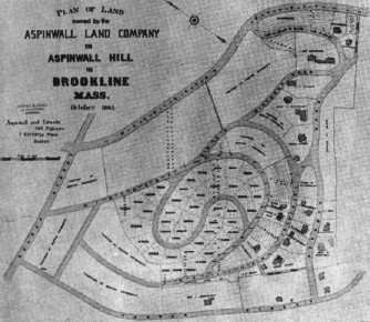
Figure 4. Plan for Aspinwall Hill – 1885.
On the basis of this incomplete series of studies and of Ernest Bowditch’s reminiscences (which have proved in other connections to be generally reliable), it is logical to conclude that Bowditch was the designer of Aspinwall Hill as it was actually laid out. The plans recorded in the Registry of Deeds at the Norfolk County Courthouse in Dedham consistently show Bowditch as the engineer for Boston University and Aspinwall as the engineer for the Aspinwall Land Company. On one plan, dated May 1883, they appear to have collaborated (however unwillingly), but at this time the Aspinwall Land Company’s property had not been completely laid out.10 In 1885, Aspinwall and Lincoln published a plan (Figure 4), but, on their lithograph, only the Aspinwall land is marked out in lots and contour lines. The major streets are in the Boston University land, and we must again assume that what we are seeing is Ernest Bowditch’s street scheme. The lithograph was undoubtedly a promotional piece, used to sell lots for the Aspinwall Land Company. But there is still one more complication. At a later date, possibly in the 1920’s, the Olmsted firm made a model of Aspinwall Hill as executed, and a photograph of this model still survives (Figure 5).
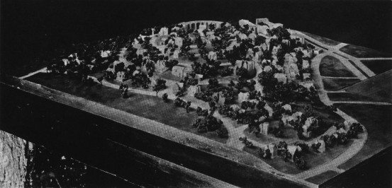
Model of Aspinwall Hill as Executed
What can we make of this very confusing story? First of all, Bowditch admitted that his own scheme was a reworking of Olmsted’s, although it appears more cramped and contorted than any of Olmsted’s studies. If the plan as executed can be attributed to the Olmsted firm at all, it is only in a very tenuous way, as a kind of step-child of the firm. (Illegitimate child might be a more accurate term.) The model can perhaps be explained in one of two ways. Either the firm considered that its plan had been appropriated, although substantially altered, by Bowditch; or, possibly, by the time the model was made, the fact that they had not done the final plan had been forgotten.
Fisher Hill
Olmsted’s next Brookline project had an uncomplicated history and a happier conclusion. Possibly in order to assure Olmsted that they were in agreement, representatives of two of the principal land owners on what is now called Fisher Hill, wrote to him in February of 1884 on the same piece of paper and asked him to make a plan for the subdivision of the Benjamin Goddard estate and adjoining “Clifton Hill” and design them as one.11
Ernest Bowditch prepared the topographical survey for Fisher Hill, as he did for many of Olmsted’s projects in Brookline and elsewhere. The subdivision was an extremely large one, bounded by Chestnut Hill Avenue, the Boston and Albany railroad tracks, Cypress Street and Boylston Street, although excluding the sizable Fisher, Lee and White estates. Except on Chestnut Hill Avenue, there were few houses in this huge tract of land. In contrast to Aspinwall Hill, the six owners must have acted in accord, for their names are listed on the face of Olmsted’s lithographed plan of December 1884 (Figure 6): George A. Goddard; the Goddard Land Company (estate of Benjamin Goddard); Mrs. L. S. Rogers; Joseph H. White; Arthur Rotch; and Jacob W. Pierce. As at Aspinwall Hill, where William Aspinwall continued to occupy his house on Washington Street adjacent to the subdivision, at least one of the owners, Joseph H. White, retained his Boylston Street home, and the Benjamin Goddard house, although moved, was also preserved.
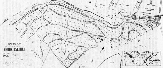
Olmsted’s Plan for Fisher Hill
The Brookline Atlases from 1888 on show that the subdivision was laid out almost exactly as planned, although it was constructed in stages, thus accounting for the fact that most of the houses on Fisher Hill are much later than the mid-1880’s, with many being built after the turn of the Century.
Olmsted’s Fisher Hill subdivision is a masterpiece of curvilinear planning, and it has become one of Brookline’s most attractive and desirable neighborhoods. Besides preserving topography, curvilinear street planning in residential districts has a practical function. Fisher Hill lies between Brookline’s two principal east-west routes – Beacon Street and Boylston Street – but the only through road between the two, Chestnut Hill Avenue, lies on the border of the subdivision. Thus, the residential streets are not a short cut to anywhere, and through traffic is discouraged from invading the neighborhood. The continued success of this part of Brookline is due in large part to Olmsted’s foresighted planning.
Chestnut Hill (Reservoir Lane Lands)
This is another mystery project about which little is known. In January of 1888, Alfred D. Chandler wrote to Olmsted informing him that two roads were to be laid out as county ways between Boylston Street in Brookline and Hammond Street in Newton, He wanted to plan the section bounded by Reservoir Lane, Boylston Street and the Newton border. The firm’s reply was that the land was potentially attractive and desirable for a residential district and should be laid out on the basis of a comprehensive and farsighted plan, whether or not all the work was done at once.12
Apparently, the group of owners whom Chandler represented wanted to act jointly as had been done at Fisher Hill nearby. Again, Ernest Bowditch prepared a topographical survey showing, in addition to the land mentioned by Chandler, the section between Reservoir Lane and Chestnut Hill Avenue, for these owners also became involved. Except near Chestnut Hill Avenue and on a few small streets near the Newton border, the land was virtually vacant.
What happened from this point on is not very clear. The Olmsted firm began working on the project in the summer of 1888, and their studies, all drawn on Bowditch’s topographical map, were tentative and not as finally executed. No studies dated 1889 were found under this job number, and yet the roll of drawings includes a notice of a meeting of property holders on November 29 1889, at which F. L. and J. C. Olmsted were to present their studies.13 The matter seems to have been dropped at this point. Either the property owners could not agree or they decided that the time was not ripe for development. There are a few drawings for this project dated 1901-2, but, again, these do not progress beyond the study stage and do not show the streets as finally constructed. The Brookline Atlases indicate that the land was developed very gradually in the early 20th century. Possibly, the area was laid out piecemeal by the Town Engineer. A portion of it along Boylston Street was used for a time by the Chestnut Hill Golf Club.
Corey Hill
On February 25, 1889, Olmsted delivered a talk to the Brookline Club on “Our Roads and What They are Leading Us to.”14 Much of the talk was historical and dealt with European and American streets generally, but he also discussed Brookline. Olmsted felt that the most critical question for the town at that time in its history was the preservation of its topography. He praised the policy of the Aspinwall and Brookline Land Companies in restricting building within 25 feet of the road. Interestingly enough, he felt that Brookline needed no more large parks besides the Muddy River Improvement, but it should try to acquire small parcels like the summit of Corey Hill.
To an even larger extent than Aspinwall Hill, the Corey Hill development was intricately tied to the Beacon Street widening, which will be discussed in the next section of this paper. The Corey holdings, most of which had earlier been part of the Winchester farm, were extensive and spread beyond the hill itself. Deacon Timothy Corey’s house still stands on the west side of Washington Street.15 The site had long been a famous Brookline scenic spot, and a beautiful lithograph owned by the Boston Athenaeum shows the view from the hill toward Boston in 1864. Corey Hill was a prominent feature of a metropolitan park plan proposed in 1869-70.16
Brookline Atlases show that, by 1874, substantial lots of land on Corey Hill had been sold – the two largest to Jordan Marsh and Company. The widening of Beacon Street in the late 1880’s and ’90s hastened this process. Henry M. Whitney, a member of the Brookline Park Commission and owner of the West End Street Railway Company, was the prime mover behind the Beacon Street widening. He formed the West End Land Company and began buying up land along Beacon Street. Olmsted already knew Whitney in connection with Muddy River, and he had also prepared the Beacon Street plan for him in 1886. Whitney was Olmsted’s client for the subdivision of Corey Hill; the firm began preparing studies in 1889.17
There were certain “givens” limiting the design of this subdivision: Summit Avenue already crossed the crest of the hill, and a number of existing houses had to be taken into consideration. Thus, a spiral road plan could not be used, and some sort of terrace system was necessary. The West End Land Company actually owned only one section of land on Corey Hill, and the first studies by the Olmsted firm are for that section only. Later, however, the firm did plans for the entire hill, but, again, these do not progress beyond the study stage and do not correspond to the executed plan. The only possible explanation is that Whitney intended to buy up and develop the entire hill and then thought better of it. (He did not generally develop the West End Company’s land himself.) Instead, Eben Jordan eventually bought and laid out the entire hill. A lithographed plan and perspective view by Aspinwall and Lincoln, together with sales blurb, for the western slope of the hill (bounded by Summit Avenue, Beacon Street, Washington Street and the town line), is found in the Boston Public Library’s Rare Book Department. This plan appears, apparently already constructed, on the 1893 Atlas. A park on the top of the hill was not a feature of Aspinwall and Lincoln’s plan. The present Corey Hill Outlook can perhaps be attributed to Olmsted’s suggestions to the Brookline Club; it appears on the 1919 Atlas on land formerly owned by Eben Jordan.
Philbrick Subdivision (Pill Hill)
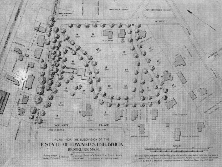
Figure 7. Plan for Philbrick Estate, or “Pill Hill.
Olmsted’s design for this small but important subdivision was executed, although with certain deviations from the published plan (Figure 7). Edward S. Philbrick, son of Samuel, the famous abolitionist, was a civil engineer and consultant on the Hoosac Tunnel construction and lived in the house at 182 Walnut Street which had been built for John Tappan.
Much of Pill Hill, except for the slope between High Street and Leverett Park, had already been developed by 1889, when Philbrick’s heirs approached Olmsted.18 (He had died that February.) Philbrick had himself built several houses on Walnut Street, and Irving Street had been laid out in 1870. Olmsted’s addition was the loop formed by Maple Street and Upland Road, an inspired treatment of a picturesque site. On a much smaller scale, the Philbrick plan has the same virtues as Fisher Hill. In each case a residential enclave was successfully set apart from surrounding through streets. On the 1889 plan, a landscaped island was shown on Walnut Street in front of the Philbrick house. Instead, an interior park was included on the triangle of land that was originally supposed to be a house lot. Philbrick’s heirs also decided in favor of privacy and reserved to themselves about four times as much land as had been first planned.
Brookline Land Company
The Brookline Land Company was formed in 1860, with an estate consisting of about 80 acres of land and extending from Washington Street in Brookline Village to Jamaica Pond and from the Muddy River Valley to High Street. It was originally known as the Ward Farm and, until 1843, had been part of Boston. By 1876, 30 acres of the estate had been sold.19
Development of this tract accelerated in the 1880’s and ’90s. Most of the land purchased by the town for Leverett Park was bought from the Brookline Land Company. With A. D. Chandler as their representative, the Land Company conferred frequently with the Olmsted firm, so that their plans would harmonize with those for the Muddy River Improvement. It was obviously in the Land Company’s interests to be cooperative, since the value of their remaining land was enhanced immeasurably by facing a park instead of a malaria-ridden swamp. The double parkway along the west side of Leverett Pond was largely the result of a meeting of minds between Olmsted and the Brookline Land Company.20 Not until 1894, however, did the Company ask Olmsted to prepare any subdivision plans, and, when they did, it was only for the triangle of land between Jamaica and Highland Roads and Pond Avenue. A plan for the layout of this area and some surrounding land had been made in 1877 by Ernest W. Bowditch.21 Two studies from the Olmsted firm exist for this subdivision, both dated August 13, 1894. The project seems to have been dropped at this point, possibly on Olmsted’s advice, for this may have been one of the lots of land which he recommended be kept open in his 1889 talk to the Brookline Club. The land was never developed but instead became first the M.I.T. Athletic Field and then, after its purchase by the town in 1912, Brookline Field.22
STREET IMPROVEMENTS
Olmsted’s plans for improving the streets of Brookline date from the mid-1880’s. For several years previous to that, the town had been involved in massive construction of new streets and rebuilding of old ones. Over a million dollars had been spent on roads and sidewalks in the decade of the 1870’s.23 The first generation of the Olmsted firm made plans for five major street improvements, three of which were executed.
Brookline Village
By 1885, a maze of little streets and private roads had grown up in a parcel of land originally owned by the Aspinwall Land Company. The land was bounded by Harvard Street, St. Paul Street, Longwood Avenue, the Boston and Albany Railroad tracks, Brookline Avenue and Washington Street. Although the land was already developed, Olmsted, at the request of the Brookline Selectmen, prepared a plan for rationalizing the street system. (A copy is owned by the Brookline Public Library as well as by Olmsted Associates.) The landowners were not in favor of the improvements, however, and comparison with Brookline Atlases shows that, except for the extension of Kent Street, the plan was never executed. In the early 1890’s, the firm was involved in the design of the Longwood Playground, located in a part of this land.24
Beacon Street
The “Great Beacon Street Widening” was possibly, of all the early Olmsted plans, the one that most radically changed the town, and for the better, according to unanimous opinion. Even Town Historian Curtis, who took a somewhat jaundiced view of the Muddy River Improvement, was full of praise for this project.25
Undoubtedly, the fact that the Beacon Street widening was a financial boon to the town in the form of increased tax revenues, as well as an aesthetic success, contributed to its universal appeal. The guiding spirit behind the project, as indicated in the section on Corey Hill, was Henry M. Whitney. Whitney saw the possibilities of Beacon Street, laid out 1850-1 as a 50-foot county way, as early as 1866, when he began buying up farms in the vicinity. In 1886, Whitney, who, besides being a Brookline Park Commissioner, was a member of the Tree Planting Committee, asked Olmsted to draw plans for widening Beacon Street to a 200-foot avenue. Whitney presented the plan to the town, offering to give the land needed for widening and to pay one-half the cost of construction. There was little opposition, although the width was reduced to 160 feet. The West End Street Railway Company, of which Whitney was President, put an electrified line along Beacon Street, and the value of the West End Land Company’s adjacent holdings increased proportionately. As noted earlier, Whitney did not generally develop the land himself, but one exception appears to have been the Hotel Beaconsfield.
Beacon Street was a logical extension of the fashionable Back Bay residential district. In his design, Olmsted was influenced by contemporary city planning in France. Like the boulevards of Paris, Beacon Street was both the principal trunkline of the district and an avenue for pleasure driving, riding, cycling and walking. To one side of the streetcar line was a bridle path where there are now parking lots. The wide driveway was reserved for pleasure traffic, while the other served commercial vehicles. (Both sides apparently had two-way traffic.) The original 200-foot plan had also included two bicycle paths and a second bridle path. Beacon Street fulfilled all expectations as a fashionable neighborhood. Among the elegant apartment buildings or “French flats” along Beacon Street are “Richmond Court,” designed by Ralph Adams Cram, and “Stoneholm,” by Arthur H. Bowditch. Sleighing was apparently a favorite use for the pleasure drive.
Beacon Street was not an isolated effort but was carefully tied in to other park and street improvements under construction at the same time. Just across the Boston line, Olmsted connected Beacon Street with the Back Bay Fens by extending Park Drive to Audubon Circle. At Cleveland Circle, Beacon Street met, Commonwealth Avenue in Brighton (another Olmsted design) to form a complete circuit at the Chestnut Hill Reservoir. The Beacon Street plan was published in The Chronicle on December 4, 1886; there are also copies at Olmsted Associates.
Chestnut Hill Avenue and Boylston Street Widenings
The Olmsted firm prepared plans for the widening of Chestnut Hill Avenue in 1891 and of Boylston Street in 1892. (Lithographs of both plans are found in the Map Collection of the Brookline Public Library as well as at Olmstead Associates.) The 1892 plan for Boylston Street included only the portion from Cypress Street to Chestnut Hill Avenue; together, the two street improvements were to frame the Fisher Hill subdivision with modern “boulevards.” Both projects were eventually carried out but only after many modifications and a decade of delay and controversy.
Boylston Street, or the Worcester Turnpike, had been a major traffic artery since 1806, but its usefulness as a modern thoroughfare was limited by the fact that its width and grade varied erratically from point to point along its course. The improvements suggested by Olmsted were held at bay by Henry Lee, a prominent citizen of Boston and Brookline, who owned the Boylston-Hyslop House overlooking the Reservoir and Turnpike. Although Lee had been a member of the Boston Park Commission from 1879-85 and had worked amicably with Olmsted during that period, he later wrote frequent and scathing criticisms of Olmsted’s plans in the public press. His campaign against the Boylston Street widening took on the dimensions of a crusade, ending only with Lee’s death in 1898. Although A. D. Chandler tried to persuade Lee that his desire to keep Boylston Street a rural road was “sentimental,” Lee maintained that Boylston Street was as worthy of preservation as the Old State House and the Old South Church. (He had played an important part in the saving of both these landmarks.) One feature of the Boylston Street widening was the introduction of the West End Street Railway’s electrified line. According to his biographer, Lee “held electric cars in especial odium … and frequent were the hostile screeds which the detestable machines called forth from him.”26
Apparently no one else took up the cause of the preservation of Boylston Street after Lee’s death, for construction began in 1900. As finally executed, the widening extended beyond the original Olmsted plan and continued from Brookline Village to the Newton line.27 Chestnut Hill Avenue was widened only slightly, and the electrified line originally intended to connect Boylston and Beacon Streets was never installed.
Proposed Brookside Roads in Upper Brookline
The final project to be considered in this paper is a plan for new roads in the part of Brookline bounded by Boylston Street, Chestnut Street, Goddard Avenue and Clyde Street.
With A. D. Chandler as their representative, eight residents of the area, including C. S. Sargent and the President of the Country Club, approached the Olmsted firm and asked them to consider what main roads and public reservations would be ultimately desirable in their neighborhood. Both the report and plan that were submitted in September of 1894 were the work of Charles Eliot, who had been Olmsted’s apprentice a decade earlier and was now his partner. A few years before, when he had had his own practice, Eliot had begun the design of the Boston metropolitan park system as a logical extension of Olmsted’s municipal system. The Brookside roads project, which, although unexecuted, has considerable historical interest, also demonstrates Eliot’s genius at metropolitan planning.
In his report, Eliot described this section of Brookline as one of the most beautiful parts of suburban Boston. (The same opinion had been expressed by A. J. Downing a half-century earlier.) With the exception of the nearby Country Club, the neighborhood was entirely residential, with sizeable estates, many of 20 acres or -more. The natural diversity of the land – the hills, valleys, and bold projecting ledges of Roxbury conglomerate – was highly picturesque, and manmade improvements – winding, walled country roads, handsome private dwellings and landscaped grounds – were exceptionally attractive. Eliot expected that this situation could not last but that the district would eventually be subdivided. At the very least, the roads would have to be widened periodically at great expense. Eliot proposed anticipating the problem by devising a new system of landscaped roads of ample width. (Although not designated as such, this was actually a plan for a system of parkways.)28
With the report, Eliot submitted a plan showing how the new improvements would relate to the rest of the southwestern suburbs of Boston and a sketch plan of the proposed Brookside Roads themselves (both located at Olmsted Associates). The main feature of the sketch plan is a broad parkway leading from Jamaica Pond to the Brookline Reservoir. Jamaica Park was under construction at this time, and the Olmsted firm had repeatedly recommended that the double road system along the west side of Leverett Park be continued by Jamaica Pond. The City of Boston eventually accepted the recommendation for the southwest side of the Pond but put in a single road on the northwest side, leaving a very narrow margin on this side of the park. As an alternate route, Eliot suggested a road going through the rear part of the present Cabot Estate development. The parkway then cut through a goodsized swatch of Sargent’s land passing right by his pond. From there it curved in back of the former home of H. H. Richardson on Cottage Street. An incomplete extension is shown from Brookline Reservoir, leading apparently to the Chestnut Hill Reservoir. To the south is another wide parkway along the approximate line of the present Lee Street, with a playground near Clyde Street and an extension going off the edge of the plan in the general direction of the Moss Hill section of Jamaica Plain. Branch roads were also suggested.
The Town did some studies based on this plan, but, except for Lee Street, it was never executed. In 1903, Brookline Reservoir was purchased from the City of Boston for a public park and was landscaped by a later generation of the Olmsted firm.29 The depression of 1894 may have been a factor in the failure of the Brookside Roads plan to achieve realization. Furthermore, C. S. Sargent, although one of the clients, may not have been pleased that so much of his land was affected. It should also be remembered that, like the Chestnut Hill subdivision, this plan was intended as a guide for the future rather than as something to be acted on immediately.
The Brookside Roads plan was not without precedent. In 1875, Ernest W. Bowditch published a plan for a system of metropolitan parks encircling Boston. Many of the sites were later incorporated into Eliot’s plan. A feature of Bowditch’s proposal was a connecting park or parkways from Jamaica Pond to Brookline Reservoir and Chestnut Hill Reservoir.30
In 1901-2, the Olmsted firm prepared a series of studies for Chestnut Hill Parkway, still another elaboration of the Bowditch/Eliot plan. This project could only have been executed as part of the metropolitan park system, since, although it lay almost entirely in Brookline, it touched both Brighton and Jamaica Plain. In spite of the fact that it was championed vigorously by A. D. Chandler and a number of other citizens, the Chestnut Hill Parkway plan was rejected by the Metropolitan Park Commission.31 But the current Charles-to-Charles project includes easements along the Cabot Estate and Hellenic College sites on the west side of Jamaica Pond, so, in at least a few of its details, the century-old plan is not yet dead.
Eliot’s prognostications about the future of the area, although entirely reasonable, turned out to be wrong, for this part of Brookline has never been intensively developed. As can be seen from the plan, Olmsted’s home was quite close to the proposed Brookside Roads. If Olmsted were to return to his old neighborhood today, he would Find it remarkably unchanged, and even Downing would still recognize its “Arcadian air of rural freedom and enjoyment.”32
SUMMARY
One can hardly imagine Brookline without the Muddy River Improvement, Leverett Park, the widened Beacon Street and its subsequent development, or Fisher Hill, Although F. L. Olmsted, Sr. retired in 1895, the firm was ably continued by his sons, John and Frederick, Jr., and by their successors, but the many fine Brookline plans done by later generations of the firm are beyond the scope of this paper. Some of the plans discussed here were not executed, but, significantly, such developments as Aspinwall and Corey Hill were not inconsistent with what Olmsted would have done himself.
From the beginning of his career, Olmsted advocated a comprehensive and far-sighted approach to town, city and regional planning. This was the philosophy behind Riverside and his other community designs. It was also the kind of planning that the town of Brookline had been quietly practicing for decades. In Brookline, Olmsted discovered a climate receptive to his ideas, and he, in turn, contributed to a tradition of progressive town planning that far outlived his own career.
NOTES
1. The principal biographical source for Olmsted is Laura Wood Roper, FLO: A Biography of Frederick Law Olmsted (Baltimore: Johns Hopkins University Press, 1973).
2. The Chronicle, March 2, 1889. Review and summary of a talk by Frederick Law Olmsted to the Brookline Club.
3. See the author’s unpublished doctoral dissertation, Cynthia Ridgway Zaitzevsky, “Frederick Law Olmsted and the Boston Park System,” Harvard University, Department of Fine Arts, 1975. The Muddy River Improvement is the subject of Chapter IV, 160-201. The Boston park system material will be expanded in the author’s forthcoming book on the same subject, to be published by Harvard University Press.
4. John C. Olmsted, “The Boston Park System,” Transactions of the American Society of Landscape Architects, Vol. 1, 1899-1908, 49-50.
5. John C. Olmsted, “Verbatim Notes and Summary Notes of a Perambulatory Tour through the Boston Park System with Pettigrew,” 1910, Summary Notes from Tour of October 7, 2, typescript (xerox), Frances Loeb Library, Harvard Graduate School of Design, Cambridge, Mass.
6. Sam Bass Warner, Jr., Streetcar Suburbs: The Process of Growth in Boston, 1870-1900 (New York: Athenaeum, 1969), 132-41. An excellent discussion of subdivision planning is found in Arthur J. Krim, Survey of Architectural History in Cambridge, Report Five: Northwest Cambridge (Cambridge, Mass.: Cambridge Historical Commission, 1977), 37-55.
7. The chronology given by Frederick Law Olmsted, Jr. and Theodora Kimball seems to indicate that there were many more than six subdivisions in Brookline [Frederick Law Olmsted, Jr. and Theodora Kimball, Frederick Law Olmsted, Landscape Architect, 1822-1903 (New York: Benjamin Blom, Inc., 1970, reissue of the 1922-8 edition), 26-391. However, the references in this chronology are not alway’s specific, and it is possible that the same subdivision was listed more than once. In the case of both subdivisions and street improvements, I have discussed only those projects for which I have been able to locate drawings. Documentation for additional projects may well come to light through further research.
8. Aspinwall and Lincoln, “Map Showing Location of the Property of the Aspinwall Land Company in Brookline and Boston,” lithograph, 1880. (Brookline Public Library).
9. Ernest W. Bowditch, “Memoirs,” ca. 1917 (unpublished, privately owned), np. The Boston University Archives contain no plans for this subdivision, although it is mentioned in the Annual Reports (R.W. Husted, “Treasurer’s Report,” in Boston University, Annual Reports for the-Years 1882-9).
The set-to between the Bowditch and Aspinwall sons reflected similar confrontations between their fathers. A contemporary reported that during town meetings.
“Mr. William Aspinwall and Mr. William 1. Bowditch never failed to take a prominent part in the discussion and always took the opposite sides of each question. When they really got going in good form the fur would fly. Mr. Bowditch explained the difference between their individual characters in this way, ‘I am firm, but Mr. Aspinwall is damned pig-headed.’ “
[Dr, Carleton S. Francis, quoted in John Gould Curtis, History of the Town of Brookline (Boston and New York: Houghton Mifflin Company, 1933), 308.]
10. Thomas Aspinwall, Engineer for the Trustees of the Aspinwall Land Company and Ernest W. Bowditch, Engineer for the Trustees of Boston University, “Plan of Land in Brookline, Mass., belonging to Trustees of the Aspinwall Land Company and Trustees of Boston University,” blueprint, May 1883, Planbook No. 9, 372, Registry of Deeds, Norfolk County Courthouse, Dedham, Mass.
11. William S. Eaton to Frederick Law Olmsted and George Goddard to Frederick Law Olmsted, February 1, 1884, Olmsted Papers, Library of Congress, Washington, D.C.
12. Alfred D. Chandler to Frederick Law and John Charles Olmsted, January 4, 1888; (John Charles Olmsted’?) to A. D. Chandler, January 5, 1.888, Olmsted Papers, Library of Congress, Washington D.C. For Chandler, see The Chronicle, September 1, 1923.
13. Notice of a Meeting of Owners of Property between Boylston Street and Chestnut Hill Avenue in Brookline and Hammond Street at Chestnut Hill, November 22, 1889, signed by George White and A. A. Ranney, Trustees, Jacob W Pierce and Charles A. Miller (Olmsted Associates, Brookline, Mass.)
14. The Chronicle, March 2, 1889. A draft of this paper is located in the Olmsted Papers, Library of Congress, Washington, D.C.
15. Nina Fletcher Little, Some Old Brookline Houses (Brookline: Brookline Historical Society, 1949), 147-50.
16. Uriel H. Crocker to Joint Special Committee, in City of Boston, Document No. 123-1869. Also published in Map and Description of Proposed Metropolitan Park for Boston (Boston 1870).
17. John Charles Olmsted to H. M. Whitney, March 11, 1889, Olmsted Associates Papers, Library of Congress, Washington, D.C.
18. Margaret Henderson Floyd, ed., Brookline Village Walking Tours (Brookline: Brookline Historical Commission and Brookline Planning Department, 1977), 16-28.
19. Shedd and Edson, “The Estate of the Brookline Land Company,” 1860 (Brookline Engineering Department); Brookline Land Company, Report to the Shareholders (privately printed, 1876).
20. There is considerable correspondence between A. D. Chandler and the Olmsted firm on this point (Olmsted Papers and Olmsted Associates Papers, Library of Congress, Washington, D.C.
21. Ernest W. Bowditch, Landscape Gardener, “Villa Sites as Arranged for the Brookline Land Company,” blueprint, July 1877, Planbook 7, 278, Registry of Deeds, Norfolk County Courthouse, Dedham, Mass.
22. Elmer Osgood Cappers, History of the Free Hospital for Women, 1875-19 75 (Boston: Boston Hospital for Women, 1975), 46.
23. Curtis, Brookline, 281.
24. Vote of the Office of the Selectmen, Brookline, February 2, 1885, Olmsted Papers, Library of Congress, Washington, D.C.; Town of Brookline, Report for the Year Ending January 31, 1886, 67; Town of Brookline, Report for the Year Ending January 31, 1894 (fold-out plan of Longwood Playground by Olmsted, Olmsted and Eliot).
25. Curtis, Brookline, 297-300; The Chronicle, December 4, 1886. The Beacon Street and Commonwealth Avenue, Brighton plans (Chestnut Hill Circuit) are discussed in Zaitzevsky, “Olmsted and the Boston Park System,” 68-73.
26. John T. Morse, Jr., Memoir of Colonel Henry Lee (Boston: Little, Brown and Company, 1905), 195-6.
27. Report of the Town Engineer in Town of Brookline, Report for the Year Ending February 1, 1901, 10-14.
28. Olmsted, Olmsted and Eliot, “Report,” September 8, 1894, Olmsted Papers, Library of Congress, Washington, D.C.; A. J. Downing, A Treatise on the Theory and Practice of Landscape Gardening, 6th ed. (New York: C. M. Saxton, Barker; San Francisco: H. H. Bancroft and Co., 1860), 40-1.
29. Report of the Park Commissioners in Town of Brookline, Report for the Year Ending January 31, 1904, 42. The 1897 Brookline Atlas, compiled and edited by French and Bryant, Engineers, shows almost all of south Brookline, including the Sargent Estate and the Country Club, covered by a network of proposed new streets.
30. Ernest W. Bowditch, “Rural Parks for Boston” (Boston: January 9, 1875). Copies of Bowditch’s plan are located in the Map Collection of the Brookline Public Library and the Rare Book Department of the Boston Public Library.
31. A. D. Chandler, “The Proposed Brookline Parkway Including the Reservoir: A Statement,” Reprinted from The Chronicle, December 27, 1902.
32. Downing, Landscape Gardening, 41.
ILLUSTRATIONS
Figure 1 – “View from Longwood Avenue Bridge.” (from City of Boston, City Document No. 22-1897).
Figure 2 – “Leverett Pond.” ca 1900. (Courtesy Brookline Public Library)
Figure 3 – F. L. Olmsted, “Study for Aspinwall Hill (Copy of first plan), Pencil and color on lithographed survey of June 1880 by Aspinwall and Lincoln. (Courtesy Olmsted Associates)
Figure 4 – Aspinwall and Lincoln, Civil Engineers, “Plan of Land owned by the Aspinwall Land Company on Aspinwall Hill in Brookline, Mass.,” October 1885, lithograph. (Courtesy Olmsted Associates)
Figure 5 – Photograph of Model of Aspinwall Hill, nd. (Courtesy Olmsted Associates)
Figure 6 – F. L. and J. C. Olmsted, “General Plan for Subdivision of Properties on Brookline Hill,” December 1884, lithograph. (Courtesy Olmsted Associates)
Figure 7 – F. L. and J. C. Olmsted, “Plan for the Subdivision of the Estate of Edward S. Philbrick, Brookline, Mass.,” May 22, 1889, lithograph. (Courtesy Olmsted Associates)
AUTHOR
Cynthia Ridgway Zaitzevsky did her doctoral dissertation at Harvard University on Frederick Law Olmsted and the Boston Park System. She has taught at both Harvard and Boston Universities and is a consultant in architectural history for such organizations as the Boston Landmarks Commission and Boston 200. She wrote “Boston’s Uncommon Parks” as part of the Boston 200 Broadside Series for the Bicentennial. She is a resident of Brookline.
FALL MEETING – OCTOBER 2, 1977
The Fall Meeting of the Brookline Historical Society was held on Sunday afternoon, October 2, 1977, at “Fairsted,” the home and offices of Frederick Law Olsted, at 99 Warren Street. The meeting, which was the culmination of an “Olmsted Weekend” in Brookline, took place in the Upper Drafting Room of the Olmsted studios, and Cynthia Zaitzevsky, a noted Olmsted scholar, presented a paper with slides, entitled “Frederick Law Olmsted in Brookline: a Preliminary Study of His Public Projects.” Sherry and biscuits were served by the Hospitality Committee following the meeting.
Other events of the Olmsted Weekend included a Walking Tour of Muddy River Park, led by Mr. Richard Heath of Boston on October 1 and followed by a reception at the Boston Hospital for Women, an exhibit at the Main Library of photographs from Mr. Heath’s collection on “Olmsted in Brookline: Leverett Park and the Muddy River Improvement,” and a bicycle tour. Sponsors who helped arrange these pleasant and instructive events, in addition to the Brookline Historical Society, were the Brookline Public Library, the Brookline Conservation Commission, and the Boston Hospital for Women.
The Brookline Chronicle-Citizen contributed much to the success of the Olmsted Weekend by publishing several articles about Frederick Law Olmsted and his work before and during the time of the scheduled events.